|
http://www.foreignaffairs.com/
The Rhine-Danube Canal
By Anonymous
From our April 1930 Issue
A CONSTANTLY navigable waterway through the heart of Europe, from the North Sea to the Black Sea, is now being constructed. Twice before it has been attempted. More than a thousand years ago Charlemagne tried to join together two tributaries of the Danube and Main Rivers, but geological conditions and heavy rains defeated his engineers. Nearly a century ago Ludwig I of Bavaria built a canal connecting the Main below Bamberg with the Danube at Kelheim. But this 107-mile canal, with its 100 locks and its capacity limited to 120-ton ships, went down to defeat before its latest competitor, the railroad; for while the upper reaches of the Danube and the Main are not always
navigable, steam power is always on tap. And so the traveler through Nürnberg today sees from the train a deserted waterway.
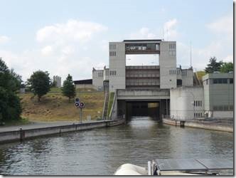
Determined to overcome the obstacles that were fatal to their predecessors, twentieth century engineers plan to make use of the 388 miles of navigable river from Rotterdam to Aschaffenburg and of the 1,362 miles of the navigable Danube from Sulina to Passau, and to construct from Aschaffenburg on the Main to Passau on the Danube — a distance of 380 miles — a waterway navigable for 1,500-ton ships (i.e., the largest ships usually engaged in inland traffic). They will also give Augsburg and Munich shipping connections with the canal.
By a treaty signed in 1921 the German Government and Bavaria agreed jointly to construct a Rhine-Main-Danube waterway. The Rhine-Main-Danube Company, of Munich, was formed for the purpose, and the stock was subscribed to by the Reich and Bavaria, as well as by other German states, by cities along the Rhine and Main, and by the public; all loans to the company are jointly guaranteed by the Reich and the Bavarian Government. The American public is interested in the company to the extent of about $6,000,000. As the Main had already been canalized as far up as Aschaffenburg, the company first set out to canalize the river above Aschaffenburg and to regulate the Danube, so that these two stretches of river will be constantly navigable. When this work is completed, it will be necessary to cut a canal connecting the two rivers, and it is planned to merge into the new waterway parts of the Ludwig Canal, which is being considerably widened and deepened to meet the demands of twentieth century river traffic.
A channel with a minimum depth of six feet has already been completed for a distance of 100 miles above Passau, and a dam and double locks have been constructed at Kachlet. Canalization of the Main above Aschaffenburg is proceeding rapidly; a dam at Obernau, about six miles above Aschaffenburg, is already in operation, and three others, at Kleinwallstadt, Klingenberg and Kleinheubach, are now under construction.
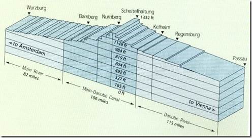
In order to pass over the range of mountains separating the Main valley from the Danube, the waterway will have to accomplish a rise of nearly 1,000 feet from Aschaffenburg to the summit level, near Hilpoltstein, and then descend about 400 feet to Passau. This will be done by constructing 52 dams, and the locks will be so placed that ships will be able to proceed in the canal at an average speed of six miles per hour. In order to be assured of sufficient water for working the locks of this canal, a reservoir will be constructed at Hilpoltstein, to be fed by a canal about 45 miles long, which, crossing the Danube by aqueduct, will tap the River Lech below Augsburg.
From the financial point of view probably the most valuable asset of the canal is the hydroelectric power stations to be erected at 38 of the 52 dams. It is estimated that the profits derived from the sale of power will within twenty-five years pay off the construction costs of each plant, and thereafter will contribute annually to the amortization of the capital invested in the waterway itself. When all the power plants are in operation, they are expected to yield 1,475,000,000 kilowatt hours annually. The Kachlet plant, above Passau, consists of eight 8,000-horsepower turbines with an annual capacity of 275,000,000 kilowatt hours; this electrical energy is carried by cables to Nürnberg and Furth. Each of the four power plants on the Main, mentioned above, has two turbines yielding between 18,000,000 and 22,000,000 kilowatt hours annually. With such a great source of electrical energy, Middle Germany, though far from good coal supplies, will soon enjoy plenty of power for her metallurgical and electro-chemical industries, and also for other industries and perhaps even for her railroads. Abundant electricity for industry will doubtless create new values for Austria also.
The total cost of constructing the waterway has been estimated at $185,000,000, and the annual operation and maintenance cost are put at $800,000. But as sections of the waterway are completed, they may (at the request either of the Reich or of the company) be taken over by the Reich, in which event the company will be relieved of operation and maintenance costs. The cost of constructing the power plants (which will pay operation and maintenance costs out of profits from the sale of power) is estimated at $70,000,000. They are to be operated by the company until the end of the year 2050, when they revert to the Reich without compensation. The present program of work calls for an expenditure of $32,500,000, nearly half of which is to be contributed by the Reich in ten annual instalments.
This trans-Europe waterway, with its western depot at London and its eastern depot at Sulina, at the mouth of the Danube, where freight can be transshipped for Russian, Turkish and Levantine ports, will be open to free competition to all countries. The Versailles Treaty declared the Danube international below Ulm (Art. 331), as also — were it ever constructed — the deep-draught Rhine-Danube navigable waterway (Arts. 331, 353); it also provided for "the free navigation of vessels and crews of all nations on the Rhine" (Art. 356). The Danube is administered by two international commissions.
Traffic on the Danube has never equalled that on the Rhine, which passes through districts much more highly developed industrially. But since the war the Danube has become much more important as an international highway. Seven independent states now have access to its waters, five of them possessing territory on both banks. For Austria, Czechoslovakia and Hungary it affords the only practicable and independent right of access to the sea. It has been estimated that the canal connecting the Rhine and the Danube would attract at least 10,000,000 tons of shipping annually. To handle this volume of traffic harbors must be extended and improved, warehouses and docks must be built, and railroad and trucking services must be improved. Czechoslovakia already possesses, at Bratislava (Pressburg), big modern docks, and Aschaffenburg and Budapest have considerable harbors. Passau and Regensburg are looking forward to enlarging their docks, and ports in Jugoslavia, Bulgaria and Rumania are planning improved accommodations.
The districts through which the canal will pass are mainly agricultural; but iron-ore deposits have been located in the highlands between Nürnberg, Bamberg and Baireuth, and the huge hydroelectric plants should, by encouraging the development of industry here, provide much traffic for the new waterway. Experts calculate that 48 percent of the total traffic on the new waterway will move westwards and 52 percent, eastwards. Germany will send to the Danubian states Westphalian coal, agricultural machines and artificial fertilizers (for both of which there is a great demand in the agricultural states of the lower Danube basin), as well as other finished products of her industries; in return she will receive agricultural products, timber and oil. Hungary, Jugoslavia and Bulgaria will benefit by the cheaper rates of water transportation for sending their surplus grain up the river to Czechoslovakia and southern Germany. Before the war, the regions now contained in Czechoslovakia produced about 75 percent of the industrial output of Austria-Hungary; this must now be exported, and, as Germany offers no market, it should logically be sold in Hungary and the other Danubian states, rather than as now in countries far distant, often overseas.
But important as the waterway undoubtedly will be to the Danubian states, they will not benefit from it alone. France is interested in it because, in Alsace, she is again on the Rhine. Great Britain is interested, because of the possibilities it opens for the Levant trade and also for direct communication with the petroleum depots of Batum and Baku. Germany is interested, because she desires to revive her trade routes to the East, which is rich in raw materials. Ultimately, the waterway is of world importance, as affording a direct connection between the terminals of transatlantic shipping and the ports of the Levant.
|

